Automapki 1.6.7
Add web mapping and commonly available satellite imagery to AutoCAD
Add web mapping and commonly available satellite imagery to AutoCAD
Software Specs
Publisher:............ Automapki
License:............... Trial
Price:................... $40.00
File size:.............. 109568 MB
Downloads:.........
Release date:...... 30 Apr 2013
Last update:........ 03 Apr 2017
Publisher review for Automapki 1.6.7:
Review by: Automapki
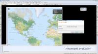
Automapki application brings web mapping and commonly available satellite imagery to AutoCAD / ZWCAD / Bricscad software. Our Automapki application allows to display your project and working area on top of your favourite web mapping source, either Bing Maps, Google Maps, Yahoo Maps or Open Street Maps. It works with standard AutoCAD / ZWCAD / Bricscad and any vertical product, supports over 3000 coordinate systems and allows the whole global CAD users community to stylize drawing entities with the selected web mapping provider.
Requirements:
Autocad
Operating system:
Windows XP / Vista / 7 / 8 / 10

Automapki screenshots:
Automapki download tags:
Autocad web mapping satellite imagery Autocad mapping web mapping satellite
Copyright information:
SPONSORED LINKS
Based on 0 ratings. 0 user reviews.
WSUS Offline Update
Popup Workshop - The Best Web Hover Ad Generator
3S Accounting
Cash Counter
IOREG
AMC Reporter
Speed Bid for eBay
Chilkat FTP C++ Library
Banker
MIETrak
Accounting and Finance
Office Suites and Tools
Inventory and Barcoding
PIMS and Calendars
Databases and Tools
Project Management
Helpdesk and Remote PC
Calculators and Converters
Vertical Market Apps
Investment Tools
Math and Scientific Tools
Other
Timesheets MTS Software
Softvoile
NewFreeDownloads
Office Suites
PIMS
Math
Calculators
Helpdesk
Databases
Accounting
Inventory