Mapwel 2017.15.0
Software for creation of custom GPS maps compatible with Garmin GPS units
Software for creation of custom GPS maps compatible with Garmin GPS units
Software Specs
Publisher:............ Balarad
License:............... Demo
Price:................... $45.00
File size:.............. 21504 MB
Downloads:.........
Release date:...... 06 Nov 2012
Last update:........ 10 May 2017
Publisher review for Mapwel 2017.15.0:
Review by: Balarad
Mapwel is software for creation of GPS maps. Supports automotive, PDA and handheld Garmin GPS units. Creation of map for GPS involves drawing of map, conversion of data into GPS native format and upload of data into GPS. Mapwel is the only available software that allows user to do above three steps with a single software tool.
Mapwel allows to draw map with use of straight lines and curves. When drawn with curves, map can be uploaded into the GPS with chosen precision/data-size ratio. Thus, you can not only draw maps faster but also accommodate the same map for various GPS units with different memory size.
Mapwel provides powerful and easy-to-use drawing tools for creation of areas, lines and other map elements. Object Inspector window displays information about map objects and simplifies the object manipulations. Map can be calibrated (synchronized) with use of the known coordinates of two spots on the map.
For your convenience, Mapwel allows you to draw the map in any colors you choose and the 'What you see is what you get' interface (WYSIWYG) shows you how the map will look like on the color or monochrome GPS display. Mapwel also simulates the Nighttime and Marine color modes.
Map can be drawn from the scanned paper chart, aerial photos and/or with use of tracks and waypoints imported from your GPS. Tracks and waypoints are automatically converted into the map elements.
User can apply Contrast, Brightness and Gamma filters to the scanned chart or photo to adjust the background for convenient drawing of vector objects on the top. Semi transparent area fills allow to draw objects on top without hiding the area beneath.
Mapwel allows user to draw map in any colors. It is useful for drawing of large maps or maps with number of land contours, for example. User can assign different color to objects of the same type. However, map transferred into GPS does not contain color data. GPS assigns colors to objects according to their type. When drawing the map, use display mode tabs (3) in the left bottom corner of the Mapwel screen to review your map in the real GPS colors.
Use Mapwel WYSIWYG workspace to create complete GPS map with filled areas, all types of lines, map features, cities, exits and points of interest with adresses. Do not limit yourself to just tracks and waypoints. Use Mapwel import capabilities to open existing maps in various formats (ESRI shape files, for example).
When converting to GPS native format, Mapwel automatically splits large objects to meet GPS technical requirements and does lot of other automation to make creation of map as easy as possible.
Upload your map directly into the GPS. Mapwel allows you to add your map to other maps already present in GPS memory. With Advanced version you can even export map into GPS native IMG file format or into widely used MP format.
Requirements:
screen resolution 1024x800
True Color display
2 gigabyte RAM
Operating system:
Windows All

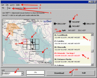
Mapwel screenshots:
Mapwel download tags:
GPS map builder map creator map editor create
Copyright information:
SPONSORED LINKS
Based on 0 ratings. 0 user reviews.