ORTWIN 8.11
ORTWIN is a program for the inquiry of the localities in Germany.
ORTWIN is a program for the inquiry of localities in Germany. It finds postal zip codes, telephone pre selections, coordinates. It performs perimeter searches and distance calculations. It finds landscapes, natural units, snow- and wind load zones.
Software Specs
Publisher:............ Killet Softwareentwicklung GbR
License:............... Shareware
Price:................... $155.00
Expire: ................ 15
File size:.............. 4.81 MB
Downloads:......... 787
Release date:...... 21 Mar 2010
Last update:........ 27 Mar 2011
Language:............ German, English
Publisher review for ORTWIN 8.11:
Review by: Killet Softwareentwicklung GbR
ORTWIN is a program for the state-wide inquiry of the localities, postal codes and telephone selections in Germany. It finds postal zip codes, telephone pre selections, coordinates and ground level elevations. The program determines municipal codes, local center points, car license codes, topographic maps, Unlocodes and much more. It arranges localities hierarchically into the structures federal state, administrative district, rural district, town, municipality, local quarter and domicile. The program performs perimeter searches and distance calculations. It finds landscapes on different levels, natural units and snow- and wind load zones of all localities. In a radius around a place or around a postal code area covered localities and postal areas can be clearly represented by a comfortable perimeter search. They can also be arranged in a list, stored as a file and printed. For the local inquiries and perimeter searches a data base with more than 120.000 geo coded localities is available. The program represents local data, determined by local inquiries and perimeter searches, in graphic overviews and data lists. The program supports conversions between different coordinate systems and the distance calculation between the places. It calculates with Gauss Krueger coordinates referring to the Potsdam Datum (Bessel ellipsoid, Rauenberg) and with Geographic Coordinates on the geodetic datum WGS84. It also works with UTM coordinates, which refer to the datum ETRS89 (GRS80, geocentric). The functionality of the program is described in a detailed electronic manual. The program can be run on most common networks and it is possible to use Terminal Services on WINDOWS Servers. The client installations are done automatically.
Requirements:
500 MHz, 500 MB Memory, 100 MB HD
Operating system:
Win2000,Win7 x32,Win7 x64,Win98,WinMobile,WinOther,WinServer,WinVista,WinVista x64,WinXP
Release notes:
Major Update
Whats new in version 8.11:
Datenbanken auf den Datenstand 1. Januar 2011 aktualisiert. Programm mit neuem CHM-Hilfesystem auf WINDOWS7 lauff�hig. Umkreissuche nach PLZ bis 100 km Radius. Um 3500 neue Ortsteile auf ca. 121000 Datens�tze erg�nzt. Neue Attribute Gel�ndeh�he, Landschaften, Naturr�ume, Schnee- und Windlasten.

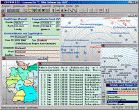
ORTWIN screenshots:
ORTWIN download tags:
local index register place locality town city cities quarter geo coding periphery perimeter search distance municipality district coordinate coordinates elevation longitude latitude snow load wind load landscape center distance transformation
Copyright information:
Based on 8 ratings. 8 user reviews.
DBDesigner 4
DB-MAIN
SQL-Front
Full Convert Enterprise
PC-Telephone
Liquid Desktop
Advanced Access Repair
ERD Concepts
Oraspeed SQL Editor
Accounting and Finance
Office Suites and Tools
Inventory and Barcoding
PIMS and Calendars
Databases and Tools
Project Management
Helpdesk and Remote PC
Calculators and Converters
Vertical Market Apps
Investment Tools
Math and Scientific Tools
Other
Timesheets MTS Software
Softvoile
NewFreeDownloads
Office Suites
PIMS
Math
Calculators
Helpdesk
Databases
Accounting
Inventory