Panoply 4.8.0.PANH6CMN
Java application which enables the user to plot raster images of geo-gridded data from net
Java application which enables the user to plot raster images of geo-gridded data from netCDF datasets
Software Specs
Publisher:............ Robert B. Schmunk
License:............... Freeware
File size:.............. 42188.8 MB
Downloads:.........
Release date:...... 29 Nov 2012
Last update:........ 13 Jun 2017
Publisher review for Panoply 4.8.0.PANH6CMN:
Review by: Robert B. Schmunk
Panoply is an utility that enable user to plot raster image. Depending on the data, it can draw global longitude-latitude images or pole-to-pole latitude-vertical images.
This program can also help you view the files created by NetCDF or other equivalent libraries.
Requirements:
Java
Operating system:
Windows All

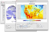
Panoply screenshots:
Panoply download tags:
plot raster image longitude image pole-to-pole image raster image raster
Copyright information:
SPONSORED LINKS
Based on 2 ratings. 2 user reviews.
WSUS Offline Update
Popup Workshop - The Best Web Hover Ad Generator
3S Accounting
Cash Counter
IOREG
AMC Reporter
Speed Bid for eBay
Chilkat FTP C++ Library
Banker
MIETrak
Accounting and Finance
Office Suites and Tools
Inventory and Barcoding
PIMS and Calendars
Databases and Tools
Project Management
Helpdesk and Remote PC
Calculators and Converters
Vertical Market Apps
Investment Tools
Math and Scientific Tools
Other
Timesheets MTS Software
Softvoile
NewFreeDownloads
Office Suites
PIMS
Math
Calculators
Helpdesk
Databases
Accounting
Inventory